In 2009, masons in Italy were cutting limestone and working on shaping them when they noticed that some slabs looked like cross-sections of a skeleton. These slabs were imported from Egypt. Paleontologists were called upon to confirm their speculation. Giovanni Bianucci, a paleontologist at the University of Pisa, confirmed that the slabs were actually the fossilized remains of a whale that swam in the waters of Egypt some 40 million years ago.
The news traveled to Philip Gingerich, a paleontologist at the University of Michigan. He wanted to visit the original site from where the slab was mined. All he knew was that the slab came from a site near the Egyptian city of Sheikh Fadl. To avoid wasting time, he opened Google Earth and zeroed in on the area some 75 miles east of Sheikh Fadl.
When he visited the area, he found a large quarry. He discovered numerous small bones and teeth. These remains belonged to small mammals that must have lived some 18 to 20 million years ago in the early Miocene Epoch. Moreover, considering the size of the bones and teeth, they were the first small mammal fossils of that age to be discovered in Egypt. Paleontologists believe that they might have been the first small mammals to have migrated from Asia to Africa when the land bridge through the Khasm el Raqaba area between the two continents was formed.
This is a startling discovery for the paleontology world as it might shed some light on how the African wildlife began.(source)
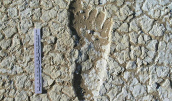
7 A Â computer programmer accidentally stumbled upon the remnants of an ancient river and the courtyards of a Roman villa while studying a map of his town.Image credits: DigitalGlobe, Google via allthatsinteresting.com
Luca Mori, a computer programmer from Italy, was casually studying the area around his town Sorbolo using Google Earth when he noticed an oval-shaped structure. It appeared to be more than 500 meters long and was quite prominent on the map. When he observed closely, he noticed that it was a curve made by some ancient river. The structure was so prominent because of the difference in moisture absorption between the old water source and the surrounding area.
Advertisements
Also, Mori discovered something else on the map. He saw a few unusual shadows that were rectangular in size. He analyzed the image properly and came to the conclusion that the rectangular structures look like a courtyard of some ancient villa. Mori then contacted archaeologists and experts from the National Archaeological Museum of Parma (NAMP). They confirmed Mori’s speculation that it was actually the remains of an ancient Roman villa.
An archaeologist at the NAMP said that they have also found remnants of other villas while excavating at Cannetolo di Fontanellato. They are trying to find out if these two are cases are related. (source)
Google Earth was responsible for the discovery of a new hominid fossil at the Cradle of Humankind World Heritage Site in South Africa. When it comes to palaeoanthropological discoveries, this is one of the most significant discoveries in recent times.
The discovery brought into limelight two partial hominid skeletons, a woman and a boy, dating to between 1.78 and 1.95 million years. Professor Lee Berger of South Africa’s Witwatersrand University has been resorting to Google Earth to identify previously unknown cave sites since 2007. He had already discovered around 600 caves and fossil deposits at the Cradle of Humankind World Heritage Site and chanced upon these skeletons when his son stumbled upon them while playing.
The discovery of the two skeletons was notable because they might provide a clue as to the ancestry line of humans. Scientists believe that these skeletons belonged to an unclassified species of advanced Australopithecus with similarities to Homo. Based on their unique and primitive anatomy, scientists believe that they may have been the immediate predecessor to Home sapiens or a close relative/branch to Homo sapiens that did not evolve into modern humans. This new hominid species has been named Australopithecus sediba. (source)
Advertisements
9 An Italian researcher landed upon the most well-preserved crater in the world using satellite imagery.Image credit: Telespazio via meteorite-times.com
A crater created by a meteorite impact was noticed via Google Earth images in 2008 by Vincenzo de Michele, a former curator of the Civico Museo di Storia Naturale, Italy. The amazing part about this discovery is that the meteor is quite well-preserved as compared to the other craters here on Earth. Some meteor curators have confirmed seeing this crater in satellite images taken in 1972.
The rim of the crater is about three meters in height, and it is surrounded by light-colored spokes of material that must have blasted out of the ground during the impact. Such fresh spoked-craters are not common on Earth and are most often found on Mars or the moon. This is because Mars and the moon have quite a thin atmosphere that limits the number of environmental processes that lead to erosion of the craters. It’s a wonder how this specific crater on Earth has been so well-preserved.
Also, since the crater is so well preserved, it will help scientists gather information on impacts caused by small-scale meteorites. They will also get to assess the hazards caused by such small-scale meteorites. This is a big opportunity as most of the small meteorites burn up as soon as they enter the atmosphere and do not even get the chance to reach the ground. (source)
Advertisements
10 A massive 853-foot ancient tidal fish trap was found that was built in the 11th century.Image source: dailymail.co.uk
An 853-foot-long fish trap was discovered off the British coast via aerial photographs that were taken by Google Earth. Scientists believe that the trap must have been built some 1,000 years ago. The strange underwater shape was first noticed by a plane flying over it. Archaeologists were then notified and they took a closer look with the help of Google Earth.
The trap, which is V-shaped, provided scientists with valuable insights on how people from the medieval ages survived on hunting and fishing. Dr. Ziggy Otto, a marine environment lecturer at Pembrokeshire College, was part of the team to have visited the fish trap and he says, “It would have taken a number of fishermen to work on a structure of this size. The fish were herded into the trap, and when the tide went out they would be scooped out with nets.”
Over centuries, the structure has metamorphosed from a man-made fish trap to a fully sustainable, natural reef. (source)


")