The 16,000km Long Mid-Atlantic Ridge Holds the Secrets of Continental Drift
The mid-Atlantic rift provides the key to understanding how continents changed over hundreds of millions of years. The vast underwater mountain range represents the boundary between the North American and Eurasian tectonic plates, which are moving increasingly apart even today. Iceland is one of the places where this geologic spectacle is on full display. Did you know you can witness the mid-Atlantic rift phenomenon above sea level in Iceland? Want to learn more about this phenomenon? Then, keep reading.
Table of Contents
The Mid-Atlantic Ridge, Stretching over 9,000 Miles, Was Discovered in the 1950s

The mid-ocean ridge is a vast underwater mountain range that runs right down the middle of the Atlantic Ocean.
Scientists didn’t even know it was there until the 1950s. But once they discovered it, everything started to make sense. It explained why the continents on both sides of the Atlantic were slowly drifting apart. To this day, the ridge continues to grow as the North American and Eurasian plates move away from each other in the north, and the African and South American plates separate in the south. They are separating in opposing east and west directions at a rate of about 2.5 centimeters per year.

The mid-ocean ridge rises above sea level in Iceland and reaches a depth of over 4,000 meters in the Cayman Trough, with an average depth of 2,500 meters to its crest (peak). This ridge is the longest mountain range on the entire planet, which is truly mind-blowing.
The Mid-Atlantic Rift Is Where the Bottom of the Atlantic Ocean Gets Wider as the Pieces of Earth’s Crust on Either Side Slowly Move Apart

The mid-Atlantic ridge, or mid-Atlantic rift, stretches from way up north, just below the North Pole, all the way down to a tiny island called Bouvet Island near Antarctica.
The Mid-Atlantic Ridge (MAR) features an axial rift valley along its length, several transform faults, and a height of roughly three km above the ocean floor. Its width ranges from 1,000 to 1,500 km. In the North Atlantic, the MAR divides the North American Plate from the Eurasian Plate, and in the South Atlantic, it divides the South American Plate from the African Plate.
The Mid-Atlantic Rift Constantly Creates New Ocean Floors Through Volcanic Eruptions, Leaving a Record of a Spreading Seafloor Â

When the mantle moves upward beneath the ridge, lower pressure makes the hot rock melt. On Earth, this process leads to explosions that create basaltic volcanoes, while underwater eruptions form unique pillow lava structures.

As the tectonic plates split up, more oceanic lithosphere is formed near the ridge, expanding the ocean basin. This process, known as “seafloor spreading,” results in a balanced arrangement of previous oceanic rocks as they migrate away from the center ridge.
The magnetic features of erupting basalt provide insights into seafloor spreading. The Earth’s magnetic field experiences periodic reversals, causing the North and South magnetic poles to alternate positions throughout time. During an eruption, the magnetic properties of small magnetic minerals within basalt change in response to alterations in the magnetic field direction.

When the Earth’s magnetism reverses from its normal state, the rocks along the Mid-Atlantic Ridge record this shift. The rocks’ variations in how they respond to magnetism result in an alternating pattern of “magnetic stripes” on the ocean floor that look similar to barcodes. The stripes indicate how old the rocks are as they move out from the crest.

The significance of magnetic stripes was only revealed after determining when magnetic reversals occurred in volcanic rocks on land. Using this information, scientists discovered that the ocean floor moves from the Mid-Atlantic Ridge into the Atlantic at a pace of approximately 0.02 meters annually.
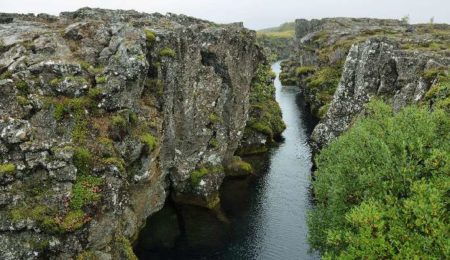
At Thingvellir National Park, Iceland, Located Along the Mid-Atlantic Rift, You Can Witness the Signs of Ongoing Geological Transformation.

Iceland sits at the junction where the Eurasian and North American tectonic plates drift apart.
There are many other places where these plates are drifting apart, but all of them are hidden underwater. However, that is not the case in Iceland, where you can witness the mid-Atlantic rift in Thingvellir National Park. The underwater ridge rises above the surface there. This massive geological rift has resulted in breathtaking landscapes, including steep cliffs and Iceland’s largest natural lake.

Thingvellir National Park has been changing for the past 10,000 years. The change in appearance is due to earthquakes and the spreading and sinking of the Earth’s crust. According to measurements, the valley’s bottom has dipped by 131 feet (40 m) and expanded by 230 feet (70 m) during the past 10,000 years.

Another interesting fact is that the mid-ocean ridge is responsible for the volcanic activity that created Iceland in the first place.
As the North American and Eurasian tectonic plates slowly pull apart, it causes countless fractures in the Earth’s crust underneath. Over long periods of time, these fractures progressively widen and deepen. The fractures eventually allow subterranean molten rock to rise to the surface as lava, giving rise to Iceland’s numerous volcanoes.

Even now, Iceland’s volcanoes continue to shape the island. Nearly 15 volcanoes have erupted in the past 100 years, and four volcanoes have erupted in the last three months, from January to March 2024 alone. It’s no wonder Iceland is one of the planet’s most geologically active regions!